
An Insider’s Guide to Death Valley National Park
Posted by Joel Patenaude on 20th Apr 2021
Death Valley—spanning 3.4 million acres across southern California and spilling into Nevada—is the largest national park south of Alaska. It is the hottest and driest spot in in North America. East of the Sierra Nevada mountains, Death Valley gets just two inches of rainfall annually and has recorded temperatures as high as 134 degrees Fahrenheit in Furnace Creek.
As inhospitable as Death Valley may sound, evidence of human habitation goes back 9,000 years. Declared a national monument in 1933 and expanded into a national park in 1994, today nearly a million people visit this remote desert annually.
Death Valley, between the Great Basin and Mojave deserts, includes a 200-square-mile salt pan (the residue of a saline lake that existed 20,000 years ago) as well as sand dunes, canyons, and mountains.
Classic Adventures
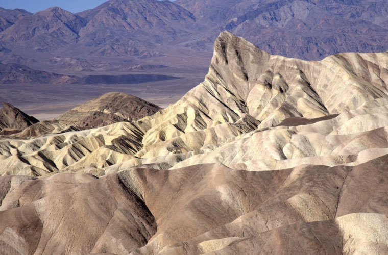
Zabriskee Point. Dzung Tran
Naturally, endurance athletes have taken on the challenge of getting from point A to point B. Several people attempted to complete the distance before 1987, when the 135-mile Badwater Ultramarathon became a competitive race, one of the toughest in the world. Held every July—the hottest time of the year in Death Valley—only runners who have proven they can go the distance are invited to participate.
The race now ends at Whitney Portal 2,548 feet above sea level. But many competitors continue beyond the finish line to bag the summit and complete the original course. Still others make the return trip on foot. And then there’s the likes of Marshall Ulrich who, in 2001, completed the “quad Badwater” (two back-to-back, round-trips) in 10 days and 13 hours. Just to finish the base 135-mile distance is an extraordinary feat for anyone.
Each October there’s also a bicycling race, the Furnace Creek 508 (also put on by AdventureCORPS), that crosses 10 mountain passes before winding through Death Valley and the Mojave Desert. The 508-mile course, including more than 30,000 feet of climbing, has a 48-hour time limit to complete. It’s not surprising that up to 40 percent of those who start the race drop out before finishing it.
Of course these folks are outliers among the visitors to Death Valley. Most people are content to take driving tours, say to Zabriskie Point to watch the sun rise over the valley. Others take short day hikes and bike rides within the vast park, making sure to set out at the coolest times of the day. Horseback riding and bird watching are popular activities, too.
A middle ground adventure (between a days-long death march or spin and just dashing from an air-conditioned vehicle into an air-conditioned visitor center) would be an all-day hike to the summit of Telescope Peak, the highest point in Death Valley at 11,049 feet. There's a 14-mile, round-trip option from Mahogany Flat and a more advanced 30-plus-mile, there-and-back route from Shorty's Well at the intersection of West Side and Hanaupah Canyon Roads. The latter starting point lies at 262 feet below sea level, so the elevation gain to the summit is substantial and something you can brag about bagging.
The best mountain top overlook of Death Valley, however, is Dante’s View, reached via a paved access road east of Furnace Creek on Highway 190)
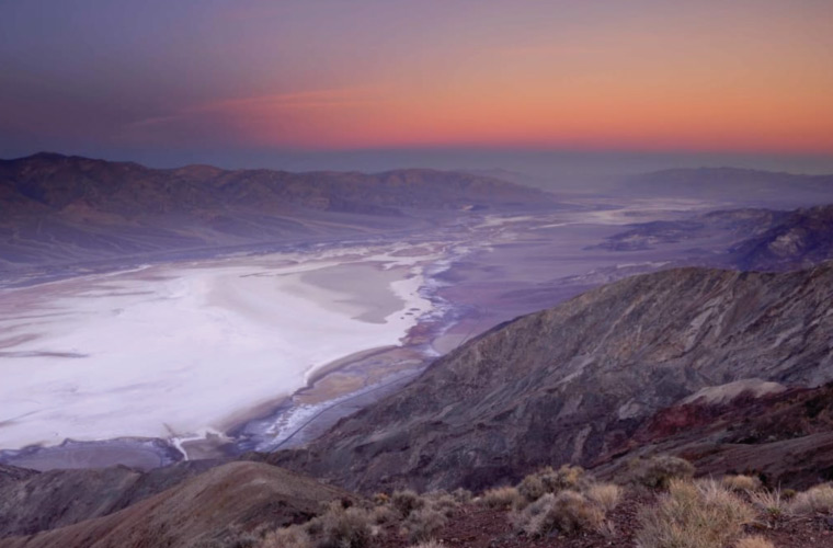
Dante's View. Joel Henner
If your bravery is more limited, leave the air conditioning of your vehicle and walk the mile-long Golden Canyon Interpretive Trail or Salt Creek Interpretative Trail. From October through March, ranger-guided walks and evening programs are offered at the Furnace Creek Visitor Center . From there you can lope along the quarter-mile Harmony Borax Interpretative Trail and see remnants of the late 19 th century borax mining that put Death Valley on the map for American industry.
Secrets of the Park
Lodging options runs the gamut. You can pamper yourself at one of four resorts in central Death Valley, including the luxurious Furnace Creek Inn and Ranch Resort . The U.S. Park Service operated nine campgrounds and there are another couple under private ownership. Or you can obtain a permit to camp overnight, which is permitted within two miles of the main roads and a quarter mile from water sources.
Forty-five miles north of Stovepipe Wells is “Scotty’s Castle,” also known as Death Valley Ranch. Worth touring (although currently closed as of June 2016 due to flood damage), the building is more villa than castle and was never actually owned by it’s most famous resident, gold prospector and conman Walter E. Scott.
In the vicinity of Scotty’s Castle is the 600-feet deep, half-mile wide Ubehebe Crater formed by a volcanic gas explosion as recently as 300 years ago. It can be viewed from the rim, which can be circled on foot in about 90 minutes. Getting down into crater is easier than getting out again due to the loose scree, so sticking to the trail is advised.
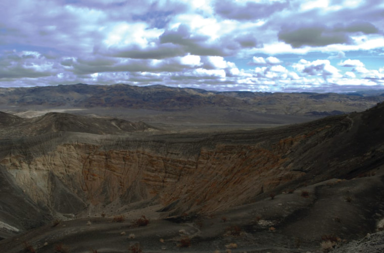
Ubehebe Crater. David Stone
A four-wheel-drive vehicle is required even on the paved roads approaching the Eureka Dunes (but not allowed off road or on the dunes themselves). You'll want to be on foot, though, to hear "the singing sand"—a unique and unexplained deep bass sounds emitted during rock slides on the steepest faces in dry conditions.
The dry lakebed road known as “The Racetrack” also requires a high-clearance, 4WD vehicle. Here rocks slide across the ground seemingly on their own, although wind and seasonal underlying ice are suspected to be the cause of their movement.
Just outside Stovepipe Wells Village is Mosiac Canyon, aptly named for the colorful, polished marble surface of its walls. Depending on the conditions, you can hike two miles in before needing to turn back.
From Panamint Springs, drive west on an unpaved road to the start of the one-mile trail to Darwin Falls. Or drive within a short walk of the Father Crowley Vista. Some 50 miles east of Panamint Springs are the architecturally curious Wildrose Charcoal Kilns, 10 beehive looking structures briefly used to fuel the processing of silver and lead ore mining in the late 1870s.
How to Get the Most Out of Your Visit
- Given that summer temperatures can reach 120 degrees F during the day and at night remain as hot as 90, that’s the season to generally avoid Death Valley. Winter and spring (October through April) temps are more mild, even requiring warm clothing at night. Higher elevations can be even chillier, of course.
- Light jacket at night in the winter and spring, shorts and T-shirts as the temps rise.
- Backcountry camping permits are required to let park staff know your general whereabouts. Otherwise you pay an entrance fee of $20 per vehicle or individual traveling by motorcycle, bicycle or on foot which allows for unlimited re-entry within seven days.
- Water, water water. Plan on drinking a gallon or more per day, depending on your activity level. Sports drinks and keep salty foods should be consumed, too. If you’re primarily exploring the park by car, bring extra water in case you break down and need to wait for assistance. And always have a map on hand.
- Ninety percent of Death Valley National Park is federally designated and protected wilderness. That said, there are nearly 1,000 miles of paved and dirt roads to providing access to its salt flats, mountains, canyons, dunes, and spring-fed oases. Photo opportunities are abundant.
- Don’t reach or step anywhere not in full view, as rattlesnakes, scorpions, and black widow spiders dwell here. Canyons are subject to flash floods, so avoid entering one during a rain storm. And stay out of mine shafts and tunnels for obvious reasons. And retreat immediately and quietly from any illegal marijuana cultivation site you may stumble across. Signs of the latter can be cleared areas, trails and litter in unusual areas.
Written by Joel Patenaude for RootsRated and legally licensed through the Matcha publisher network. Please direct all licensing questions to legal@getmatcha.com.
Share on: