
Insider's Guide to Canyonlands National Park
Posted by Sarah Kuta on 3rd Jul 2019
Canyonlands National Park offers visitors breathtaking views of deep red canyons, steep drop-offs, smooth orange arches, and rust-colored sandstone pillars. Located in eastern Utah about 30 miles west of Moab, Canyonlands is also home to the winding Colorado and Green Rivers, which beckon to kayakers and canoers.
This 337,598-acre park was first established in 1964 and expanded in 1971. For visitors backpacking, hiking, boating, climbing, horseback riding, or camping, the park affords views of multicolored rock layers, formed by millions of years of erosion. Beavers live along the rivers, while bighorn sheep and mule deer roam the rugged canyon terrain.
Classic Adventures
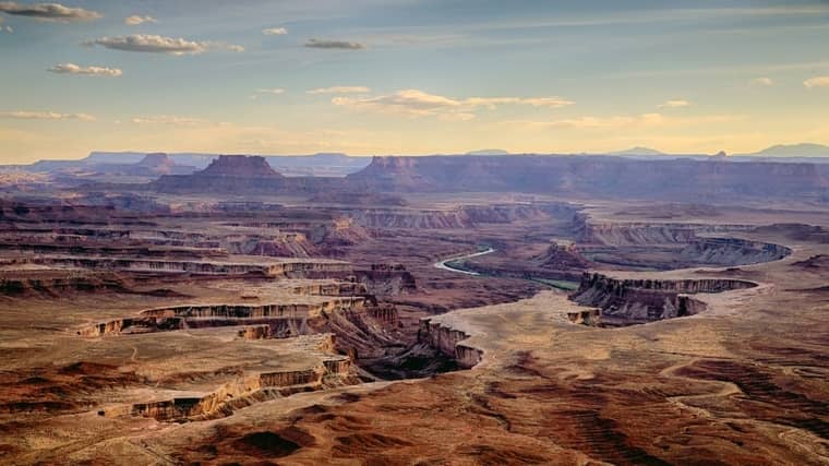
Canyonlands National Park. Chao Yen
The park is divided into five districts, with the majority of day hikes, climbing routes, and mountain bike trails located in Islands in the Sky and The Needles.
If you’re short on time, start with the popular Mesa Arch Trail. This half-mile round trip route ends at the Mesa Arch, which provides an east-facing frame for Buck Canyon below and in the distance, the La Sal Mountains. The arch is particularly photogenic in the early morning hours and at sunset.
For more of a challenge, consider the very steep Gooseberry Canyon Trail. This 5.4-mile out-and-back hike drops more than 1,000 feet in the first mile before evening out to a much gentler slope beyond that. Gooseberry Canyon boasts switchbacks and intense exposure along parts of the trail but the views of various rock layers and the canyon below are worth it.
The 5.8-mile Neck Spring loop in the Islands in the Sky district passes by the remnants of historic ranching activity, two springs, and an array of shrubs, bushes, and trees. This moderate hike includes 300 feet of total elevation change.
Mountain bikers will enjoy Lathrop Canyon trail , an 8-mile out-and-back that juts off from the popular White Rim Trail to the Colorado River. Riders will see riparian vegetation near the river, contrasted with the barren and dry terrain in the rest of the canyon.
Climbers spend most of their time on the sandstone towers of the Island in the Sky Mesa , which is located in the park’s northernmost tip and accessible via the White Rim Trail. Climbing in the rest of the park is tricky because of poor rock quality and a lack of established routes. In fact, climbing is prohibited in several areas of the park.
In Search of Suds , which is rated a 5.10+ route, is a tough climb on Washer Woman Tower (it’s named this because it looks like a woman bending over a tub doing laundry). This is one of the more popular routes in Canyonlands, in part because the summit offers spectacular views of the park below.
Secrets of the Park
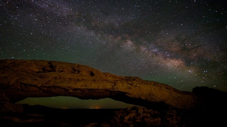
Stars above Canyonlands. Chao Yen
Canyonlands was given a gold rating in 2015 by the International Dark-Sky Association for its “authentically dark” nights. That makes this park one of the best places in the world to see the stars — thousands of them. Gaze while camping or passing through or participate in the organized stargazing events that occur throughout the summer.
The 11-mile Chesler Park Loop in The Needles District is a great hike for seeing many of the park’s spires and buttes. If you feel like backpacking, there are at least six primitive campgrounds along this route in Elephant Canyon. You’ll trek through Chesler Park, a broad valley surrounded by otherworldly rock formations, and squeeze through massive boulders.
The Lower Red Lake Canyon route in The Needles district is nearly 19 miles round trip and takes backpackers from the Elephant Hill trailhead to the Colorado River. With little shade and an elevation change of nearly 1,400 feet, this multi-day hike is difficult. It may be hard to spot the river at first when you arrive as its overgrown with wild shrubs and trees.
A less popular climbing route in the Islands in the Sky district is the Sims-Hesse-Hanning Route , a tough 5.11 route with several hand cracks and incredible views of the Green River below.
Immerse Yourself
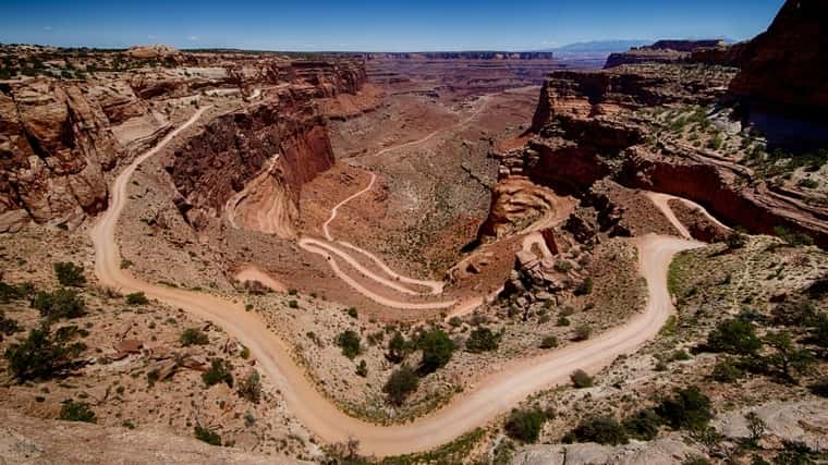
The amazing White Rim Trail. Chao Yen
Mountain bikers will appreciate the 100-mile White Rim Road Trail , which makes for a good backpacking trip spread out over three to five days as well. Campgrounds along the route are designated but remote — there are are no services along this route and an overnight stay requires a permit. This circular ride can be done in any direction, but either way, expect a steep climb at one end of the ride.
To really get away from the crowds, check out The Maze District of the park. In this remote area, you’ll need four-wheel drive, a topographical map, and a GPS device — and you need to know what to do with them.
The Harvest Scene route takes hikers to a 3,000-year-old wall of painted rock art known as the Harvest Scene Pictographs. This difficult 8.7-mile loop begins at the Chimney Rock Trailhead in The Maze district and passes through two canyons. Prepare for some steep descents and climbs, but also some incredible views of the massive Chocolate Drops formation on the canyon rim.
Cataract Canyon is an incredible way to see the park by boat. This section of the Colorado River begins at the confluence of the Green and Colorado rivers and features difficult whitewater rapids, as well as relaxing flat waters. The best time to travel by river in Canyonlands is during late summer and fall, when the water is low and you can camp on sandbars.
How to Get the Most Out of Your Visit
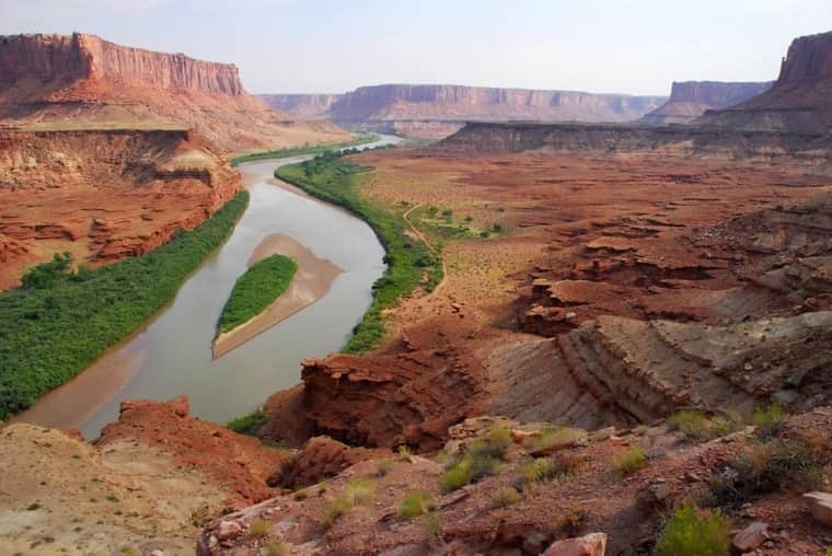
Deep in the canyon by the Green River. Rob Lee
- Drink at least one gallon of water a day and wear loose-fitting, light colored clothing that covers your body, as well as a hat.
- Plan your most strenuous activities for the early morning or early evening hours. In the summer, temperatures climb well over 100 degrees.
- Dawn and dusk are also the best times for photos at Canyonlands. The sun enhances the reds and oranges of the park’s rock formations, buttes and canyons.
- Consider a four-wheel-drive vehicle for this park. Many, many, roads, especially those in remote parts of the park, travel over rugged terrain.
- Fuel up your car before heading to Canyonlands. If you’re in a particularly remote district of the park, like The Needles or The Maze, the nearest services may be 50 miles away.
- Don’t rely on your cell phone. Service is very spotty in some areas of the park.
- Get your permits before you arrive at the park. Day-use permits are required for travel on many roads, including White Rim Road, which is popular among mountain bikers. Permits are required for backcountry camping.
- Do not collect artifacts in the park. There are many archaeologically significant sites in the park, so please keep it that way.
- Like most national parks, Canyonlands isn’t pet friendly. Pets are not allowed on hiking trails or on four-wheel-drive roads, even in your car.
Written by Sarah Kuta for RootsRated and legally licensed through the Matcha publisher network. Please direct all licensing questions to legal@getmatcha.com.
Share on: