
The 10 Best Hikes in Yellowstone National Park
Posted by Ethan Shaw on 30th Aug 2021
Yellowstone National Park can be a busy place: It’s reliably among the top five most-visited national parks in the U.S. But it’s also an enormous place (2.2 million acres), and a minority of its multimillion annual visitors actually hit the trails and head into the wild backcountry.
Bone-white geothermal basins tucked away in the Yellowstone Plateau’s doghair lodgepole pinewoods, storm-light over rolling Douglas-fir parkland in the Northern Range, a grizzly pawprint in the mud of a green swale, a herd of pronghorn spooked to high-speed flight by your presence, or a herd of bison decidedly unspooked by it—the pleasures of Yellowstone wilderness go deep. Here are 10 across-the-board hiking trails that, together, suggest something of the scenic diversity this Rocky Mountain wonderland offers.
Most of them are on the long side, but keep in mind that the short trails in Yellowstone—the one to Storm Point on the northern shores of Yellowstone Lake, say, or the walk to Wraith Falls on the flanks of the Blacktail Deer Plateau—are plenty magical (and sometimes surprisingly uncrowded).
1. The Sky Rim Trail
Mileage: 21
Difficulty: Hard
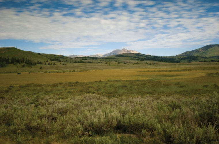
Electric Peak rising high in the distance.
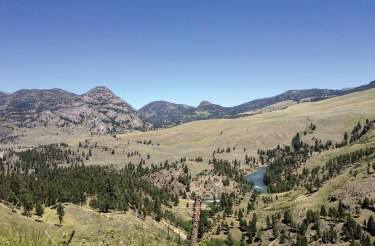
The stocky Gallatin Range makes Yellowstone’s northwest a regal alpine wilderness, and the Sky Rim Trail—tracing the park’s boundary with the Gallatin National Forest—serves up mega-scenery. Make a backpacking or big-dayhike loop of it by climbing from the Dailey Creek Trailhead to Dailey (or Daly) Pass, then hoofing along a backbone ridge to 9,889-foot Big Horn Peak, which you can summit via a spur trail. Clear-day views extend from the Madison Range and the Absarokas to the Tetons, with nearby Gallatin brutes such as Electric Peak and Mount Holmes vying for your attention. (Big Horn Peak’s namesake mountain sheep also sometimes try to steal the show.)
You can trek onward to the northeast to Sheep Mountain, one of the commanding summits of Yellowstone’s Northern Range. Otherwise, complete your loop by dropping into the Black Butte drainage and then taking the cutoff back to the Dailey Creek Trail.
The Sky Rim loop isn’t a walk in the park—well, okay, literally it’s a walk in the park, but the circuit demands more than 3,000 feet of elevation gain. Plus, the Daly Pass-Big Horn Peak section isn’t a fun place to be during one of those Gallatin thunderstorms that commonly erupt on summer afternoons: Electric Peak didn’t get its name for nothing.
2. Mount Washburn
Mileage: 5 (RT) via Chittenden Road; 6 (RT) via Dunraven Pass
Difficulty: Moderate
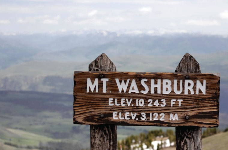
The summit of Yellowstone's Mt. Washburn.
Here’s one of Yellowstone’s stone-cold classic dayhikes. Slog to the fire lookout atop Mount Washburn, and you’ll have among the best panoramas for wrapping your head around Greater Yellowstone geography. The 10,243-foot crown of the Washburn Range sits on the northern edge of the Yellowstone Caldera (actually composed of three separate calderas), which encompasses the vast plateaus roofing the Yellowstone Supervolcano. From Mount Washburn, you look south across the caldera—the Grand Canyon of the Yellowstone, the Hayden Valley, and Yellowstone Lake all conspicuous landmarks—to the faroff Red Mountains. Once connected to the Washburn Range, these intervening highlands were destroyed in Yellowstone’s apocalyptic caldera-forming eruptions.
You can reach Mount Washburn either from the north, by the wide 2.5-mile Chittenden Road track (once tackled by Model-Ts), or via a three-mile hike from Dunraven Pass to the south. Besides the sweeping mountaintop vista—which also includes the Gallatins, Absarokas, Beartooth Plateau, and Tetons—you’ll savor ghostly groves of killed whitebark pines, rich midsummer wildflower blooms, and the strong possibility of spotting bighorn sheep—not to mention grizzlies, for which these high slopes, especially in early fall, are prime foraging ground.
As on the Sky Rim Trail, thunderstorms are a risk here. Best to start early and be off Mount Washburn by midday.
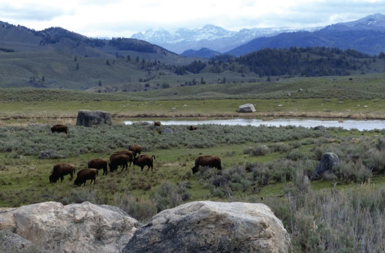
3. Specimen Ridge Trail
Mileage: 17.1 from Junction Butte TH; 17.9 from Yellowstone River Picnic Area
Difficulty: Hard
Megafauna potential near Specimen Ridge.
This is a long, strenuous dayhike that rewards with knock-your-socks-off scenery and major megafauna potential. Specimen Ridge—named for petrified trees on its flanks that were swamped by primordial lahars—forms an awesome scarp between the lower end of the Grand Canyon of the Yellowstone and Amethyst Mountain to the southeast. Its northern cliffs overlook Lamar Valley, a breathtakingly gorgeous swath of the Northern Range that well earns its “America’s Serengeti” tag.
While you can tackle the Specimen Ridge Trail from either end, an eastern approach verges on masochism given the brutal climb up the ridge from the Lamar River—better to go the other way. From the trailhead south of Junction Butte (or from the nearby Yellowstone River Picnic Area), ascend windswept parkland slopes to the high crest of Specimen Ridge. From the kettle ponds and bouldery knolls of Lamar Valley below to the enticing snarl of the Absarokas, the views astound. And you’ve got an excellent chance of seeing wildlife, from pronghorn to bighorn sheep; if you don’t see litters of faroff bison from the ridge, you’ll probably run into them as you descend into the Lamar, where their own dusty paths make the most extensive trail network.
Two major keys to a Specimen Ridge traverse (which involves some 3,300 feet in elevation gain): Carry plenty of water (the ridge tends to be parched by high summer), and check the current height of the Lamar River before commencing—that can be a dangerous or impossible ford till August.
4. Thunderer Cutoff/Cache Creek Hike
Mileage: 18.5
Difficulty: Moderate
The Lamar River Trail on a bluebird day. Ethan Shaw
This shuttle route, best done as a backpacking trip but also doable for a fit dayhiker, shows off the raw splendor of northeastern Yellowstone—from dark mountain timber to sun-blasted sagebrush glens. Start on the steep Thunderer Cutoff Trail, which ascends through deep mixed-conifer forest to the half-burnt whitebark-pine stands of Chaw Pass, up on the spine of the imposing Absaroka prow called the Thunderer. To the east, the Absarokas make a wild skyline; keep an eye peeled for the distant ridgeline keyhole of the Needle. Then switchback into the Cache Creek drainage and follow its broad valley southwest to the Lamar River. Finish by walking the Lamar River Trail a few flat miles to its trailhead along the Northeast Entrance Road.
A couple of miles above Cache Creek’s confluence with the Lamar, you’ll spot the bleached gash of Death Gulch to the south: This is the geothermal basin of Wahb Springs, named for the subject of naturalist-writer Ernest Thompson Seton’s celebrated The Biography of a Grizzly (1900). (Wahb was a grizzly bear of tremendous size and ornery disposition who, in Seton’s story, peacefully meets his maker amid the poisonous vapors of Death Gulch.)
Make plenty of noise in the thick woods of the Thunderer Cutoff—the lush stream corridors and berry thickets draw bears—and be watchful for bison along the Cache Creek and Lamar River trails. You’ll likely see pronghorn in the Cache Creek/Lamar valleys, and badgers burrow in the river terraces around the confluence.
5. Black Canyon of the Yellowstone
Mileage: 17
Difficulty: Moderate
Looking down the Yellowstone River from near the Hellroaring Trailhead.
Tracing the Black Canyon of the Yellowstone makes one of the iconic backcountry treks in the park: a compact backpacking trip or long dayhike. Through this stirring, semi-arid gorge, the Yellowstone River—fresh out of its Grand Canyon and bolstered by the Lamar River—edges the tough flanks of the Beartooth Uplift and exits the park (bound for Yankee Jim Canyon and the Paradise Valley).
Hiking from the Hellroaring Trailhead to Gardiner, Montana, you’re burrowing through the heart of the Northern Range, among North America’s greatest wild ungulate pastures. (Elk, pronghorn, mule deer, and bison all winter in this area, the lowest and least-snowy part of the park.)
Besides the raw scenery and presence of big animals, the trail offers a zinger right at the beginning: the unforgettable suspension bridge over the Yellowstone River as it surges into the Black Canyon.
6. Mary Mountain Trail
Mileage: 20
Difficulty: Moderate
Yellowstone's Hayden Valley.
The Mary Mountain Trail, which strikes through the Central Plateau’s scattered grasslands and vast pinewoods, can be a little freaky, no question. It’s not uncommon to be roadblocked by bison on this path—from hoofprints and wallows to shed wool and buffalo “pies,” their marks are everywhere here—and you should always give these real kings of Yellowstone a wide berth. And this is major grizzly country, too. Fatal attacks have occurred along this trail, so you absolutely want to be bear-aware from start to finish.
This landscape, though—from the sunny plains of the Hayden Valley to little Mary Lake in the backwoods—is part of the heart of the Yellowstone Plateau. And that tension of sharing space with big, surly beasts, well, that’s an intrinsic part of the on-foot Yellowstone experience.
7. Brink of the Lower Falls Trail
Mileage: 1.5 (RT)
Difficulty: Easy
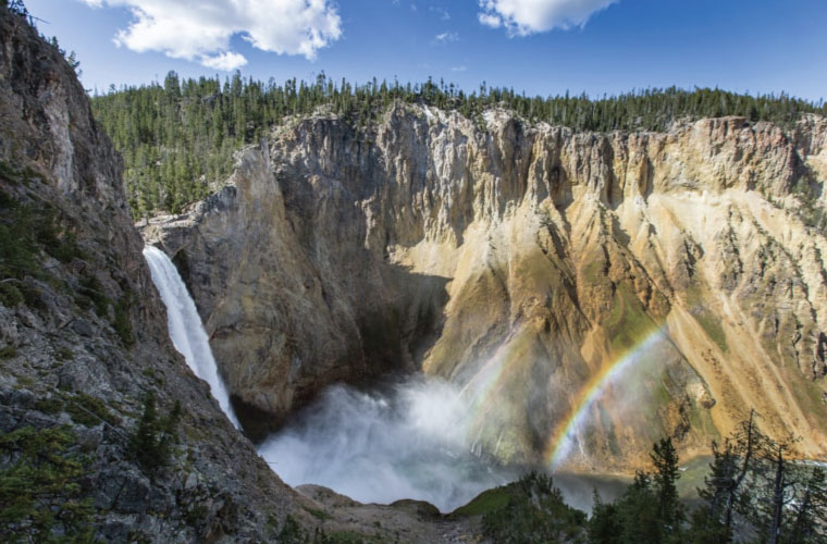
Double rainbow at the Lower Falls of the Yellowstone River.
This is by far the shortest (and most trammeled) footpath in our roundup: a mere 1.5 miles round-trip. But hey: The Grand Canyon of the Yellowstone is one of the heraldic features of the park, and the Brink of the Lower Falls Trail gives you a killer up-close view of the giant waterfall that marks its head. And don’t let the mileage fool you: The 600 steep feet you’re negotiating by switchbacks and stairs can be too challenging for some.
It’s humbling to pay your respects to the Lower Falls, the most voluminous cataract in the Rockies, as it heaves the pristine waters of the Yellowstone almost 310 feet down into the colorful rhyolitic canyon. (Farther down the defile, meanwhile, the park’s tallest waterfall, the ribbon-like horsetail of Silver Cord Cascade, streams 1,200 feet down the southern wall; admire it from the Sevenmile Hole Trail on the opposite rim.)
8. Shoshone Lake Circumambulation
Mileage: Approx. 24 (via Delacy Creek Trail)
Difficulty: Moderate
Yellowstone's Shoshone Lake.
Though well outsized by Yellowstone Lake, Shoshone Lake is still a mighty body of water: 8,050 acres in area and 205 feet deep at maximum. And it’s reachable only by foot or non-motorized boat (kayakers and canoeists get here from Lewis Lake via the Lewis Channel).
You can make a roundabout of Shoshone Lake using three different approaches (the Shoshone Lake, Delacy Creek, or Dogshead trails), but the Delacy Creek Trail offers the shortest overall: a roughly 24-mile circumambulation. Besides the prodigious beauty of the windy lake itself, you’ll also get to eyeball the dense-packed Shoshone Geyser Basin, one of the park’s richest backcountry geothermal zones.
Keep in mind: Shoshone Lake’s one of the busier corners of the Yellowstone backcountry, so make advanced reservations for your campsites.
9. The Thorofare & South Boundary Trails
Mileage: 70
Difficulty: Hard
The Absarokas in the distance.
One of the greatest backpacking routes in America, the Thorofare and South Boundary trails lead you through the Lower 48’s most remote wilderness: the valley of the Upper Yellowstone River called the Thorofare.
Kick off this epic trek from the Nine Mile Trailhead on the northeastern shores of Yellowstone Lake. You’ll trace this oceanic waterway south to the swampy delta that marks the Upper Yellowstone’s entrance into Yellowstone Lake, then head up the broad, sodden chute of the Thorofare. With the Two Ocean Plateau blockading the western skyline across the valley, the trail mostly hugs the base of the Absarokas, including the ramparts of the Trident. Then you hop the South Boundary Trail westward over the Two Ocean Plateau (which gives rise to the Snake River) and Big Game Ridge, ultimately following (and fording) the Snake to the South Entrance Station.
Though much of the hiking’s along an easy grade (save for the South Boundary Trail portion), this adventure’s still demanding: Some major river crossings are involved—foremost among them Thorofare Creek, the Yellowstone, and the Snake—and there are grizzlies aplenty. Plus, of course, you’re in the middle of nowhere.
10. Bechler River Trail
Mileage: 28
Difficulty: Moderate
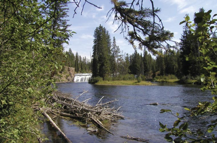
Yellowstone's Bechler River.
A worthy counterpart to the Thorofare on the opposite side of the park, the Bechler River Trail offers a gentle-grade backcountry odyssey into the unique, isolated southwestern province of Yellowstone. This is the wettest part of the park, where Pacific airmasses cruising up the Snake River Plain hit the Yellowstone Plateau and dump their payload. They call this place Cascade Corner: Rapids and waterfalls abound in the heavy woods (mostly missed by the 1988 wildfires), and there are plentiful lakes, wet meadows, and willow swamps.
You’ll hike between the Old Faithful area and the Bechler River Trailhead in the park’s southwestern corner (reached via Cave Falls Roads). In between? The standalone Lone Star Geyser; a painless (and forest-hemmed) surmount of the Continental Divide at Grants Pass; the long, lush, and waterfall-staggered Bechler River Canyon; and the marshy flats of the Bechler River Meadows.
It’s best to do the Bechler in late summer or early fall, as high water and badass mosquito legions prevail in this sodden bush earlier in the season.
Written by Ethan Shaw for RootsRated and legally licensed through the Matcha publisher network. Please direct all licensing questions to legal@getmatcha.com.
Share on: