
The Other Badlands: A Tour of American Badlands Beyond South Dakota
Posted by Ethan Shaw on 7th Oct 2019
North America doesn’t have a monopoly on badlands, but it lays claim to the best-known examples and also generated the name of this singularly rough, moonscape terrain. French trappers surveying the dry, barren, and bristling outback of South Dakota’s White River Badlands—which the native Lakota called mako-shika, variously translated as “eroded land” or “where the land falls away”—labeled it les mauvaises terres a traverser, “a bad land to travel across.”
Those White River Badlands, the centerpiece of Badlands National Park, are arguably the epitome of the landform (though Albertans might huffily point to the extensive badlands of the Red Deer Valley, well on display in Dinosaur Provincial Park). And they’re genuinely extraordinary: soaring pale ruins eaten out of the great prairie divide known as the Wall.
But the United States is full of other standout badlands, which—as long as you’re not stranded in them with a broken leg and an empty canteen—are only “bad” in the slang sense of being awesome.
But First … Geology!
What exactly are badlands, geologically speaking? Flat-lying formations of sedimentary rock such as shale and other mudstones rich in clay minerals, lacking much vegetative cover, and exposed to semiarid or arid climates often produce badlands: heavily dissected country of scalloped buttes and sharp divides, pinnacles and hoodoos, gutted by a complex, even bewildering network of gulches and coulees. The only flat ground in typical badlands is that atop the mesas or tables standing above the gullied barrens as remnants of the preexisting, uneroded land surface, or the dusty basins tucked away in the topographic chaos.
The scanty plantlife of badlands is partly due to limited rainfall, but also because the regular expansion and contraction of clay soils—swollen by rain or snowmelt, then shriveling dry—make it tough for roots to take hold, as does the lurch of freeze-thaw cycles. Without much in the way of greenery holding this dirt together, cloudbursts or thunderstorm deluges—a common mode of rainfall in the badlands-rich Great Plains and American Southwest—gouge, scour, and carve out the characteristic grooves and gullies.
Sometimes you’ll see the term “breaks” used interchangeably, or in overlap with, badlands. The Missouri Breaks of north-central Montana, for example, come plenty ruffled up with badlands terrain, as do the terrace scarps of many semi-arid rivers in the West. A basic definition of breaks is where some height of land drops down ruggedly, which could mean a line of bedrock cliffs edging a plateau or ridge but also true badlands, especially where they stagger the landscape along a broad front.
Now let’s get on with the badlands tour!
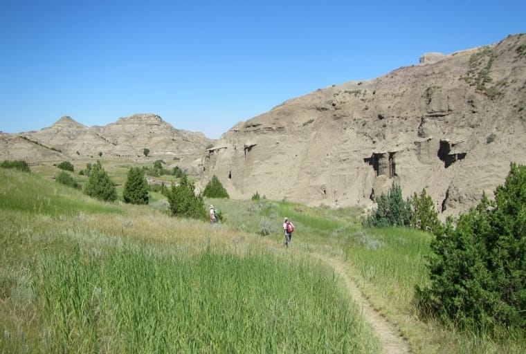
Little Missouri Badlands: Theodore Roosevelt National Park & Surroundings, North Dakota
The Dakotas both boast a bounty of badlands, Theodore Roosevelt National Park being North Dakota’s sturdy answer to Badlands National Park down south. These formations along the Little Missouri River don’t look all that much like the White River Badlands: For one thing, they’re greener, with dense juniper woodlands on many north slopes and gallery forests of cottonwood, ash, and other tall hardwoods along well-watered washes. And the Little Missouri Badlands are softer in profile, and colored with bands of lignite and red clay, or clinker, baked by burning coal; resistant clinker often tops the buttes and knolls.
Rich in geological splendor and history—can you guess which former U.S. president used to ranch these here parts?—Theodore Roosevelt National Park also comes packed with critters: Keep a sharp eye out for elk, bison, mustangs, and longhorn cattle.
Toadstool Geologic Park: Pine Ridge Escarpment, Nebraska
Boasting some of the same sort of sharp, white formations as Badlands National Park, Toadstool Geologic Park is named for the many top-heavy pillars cropping out in this Pine Ridge erosion-scape. Blocks of sandstone (derived from river deposits out of the Rocky Mountains and Black Hills) that have resisted erosion rest atop pedestals of gnawed-away siltstone, forming the “toadstools”; many of these precarious badlands structures have collapsed, but just give it (plenty of) time—more are being formed, grain by grain.
Makoshika: Missouri Plateau, Montana
The name Makoshika comes from the Lakota term for the landform. TheTurducken
A stone’s throw from Glendive and the Lower Yellowstone—and only about an hour west of Theodore Roosevelt National Park—Makoshika constitutes Montana’s biggest state park and a magnificent swath of Great Plains badlands. (You’ll recognize the name from the aforementioned Lakota term for the landform.)
Much of the partly vegetated country here derives from the Hell Creek Formation, one of the most fertile dinosaur boneyards on the planet; genuine celebrity thunder-lizards, T. rex and Triceratops among them, have been exhumed from these long-ago river and swamp deposits.
Hell’s Half Acre: Wind River Basin, Wyoming
A mere half-acre of hell doesn’t sound quite so terrible, but two things: This beautiful mess of badlands at the far eastern edge of the Wind River Basin commands more on the order of 300-plus acres, and its hellishness depends entirely on your perspective. Scoured and gullied out of sandstone and shale, the banded Hell’s Half Acre badlands include intricate pinnacles, hoodoos, and castellated scarps strung through with flats and white gulches—fortressed runways that archaeological evidence suggests American Indians used to trap bison back in the day.
Adobe Town and the Honeycomb Buttes: Red Desert, Wyoming
Wyoming’s vast, ethereal, and fought-over Red Desert occupies some 15,000 square miles of the Green River, Great Divide, and Washakie basins in that windblown, hardscrabble sag of the Continental Divide known broadly as the Wyoming Basin. It’s a desolate land of semi-arid steppe, lonesome rims and mesas, rough hills and dunes, “desert” elk and pronghorn and mustangs—and plenty of badlands, especially prevalent in the Wasatch Formation’s mudstones.
You’ve got to be motivated to track down Adobe Town, a nest of hoodoos, mushroom rocks, and barren gulches below Adobe Town and Skull Creek rims in the Red Desert’s southern outback. Somewhat less remote and more colorful are the Martian-hued badlands of the Honeycomb Buttes in the north, easily visited alongside fairly close-by Red Desert touchstone landmarks as the Oregon Buttes, Steamboat Mountain, and the Killpecker Sand Dunes. Both Adobe Town and the Honeycombs are classified as Wilderness Study Areas by the Bureau of Land Management.
The Painted Hills and Blue Basin: John Day Fossil Beds National Monument, Oregon
Badlands abound in the weathered clays and tuffs of north-central Oregon’s John Day Basin, dominated by the ancient lava flows, mudflows and ashfalls of the Clarno volcanoes, Old Cascades, and Crooked River Caldera and stacked with the lithified remnants of prehistoric flora and fauna. The two most celebrated tracts of John Day badlands lie in separate units of the John Day Fossil Beds National Monument. The Painted Hills compose mesmerizing, polychromatically banded swells of paleosols—ancient soils—weathered from lava and ash; the color gradation from red to orange to tan reflects a shift in climate from warm and wet to cool and dry.
Over in the Sheep Rock Unit of the national monument, meanwhile, you can trek into the runneled, blueish-gray amphitheater of the Blue Basin: claystone badlands derived from Old Cascade ash.
The Pillars of Rome: Owyhee River, Oregon

The Pillars of Rome are a 100-foot-tall landmark that's iconic in the region. Charles Knowles
One of the defining landmarks of the wild and lonesome Owyhee country of the southeastern Oregon outback, the Pillars of Rome form a 100-foot-tall palisade of sheer, ashen badlands eroded into ancient lakebed and riverine deposits. The resemblance to classical ruins is hard to miss (and gave the name to the nearby town of Rome on the Owyhee River).
Blast-Zone “Badlands”: Mount St. Helens, South Washington Cascades
To review: Take a barren heap of fine-grained rock bits unsecured by plant roots, add runoff and slopewash and wind, and badlands result in short order, geologically speaking. The violently ravaged “Blast Zone” of Mount St. Helens’ 1980 eruption has developed its own sort of badlands terrain on the raw spewage of the volcano, particularly in the “Hummocks” of the North Fork Toutle River valley, sculpted out of the debris avalanche formed from the mountain’s collapsed north face. The multiple hues of the Hummocks derive from different lava emissions across Mount St. Helens’ history: andesites, dacites, and basalts that once formed part of the mountaintop.
These Blast Zone badlands won’t last as long as others on this list, destined to be stabilized and vegetated in the damp Pacific Northwest climate as ecological succession hums along. But they’re a reminder that badlands can be temporary landscapes in many kinds of settings—from volcanic debris to the raw dirt piles of construction zones.
The Chinle Badlands: Grand Staircase-Escalante National Monument, Utah
At the base of the Vermilion Cliffs—the lowest riser in the mighty Grand Staircase of the Colorado Plateau—the shales, sandstones, and other sedimentary layers of the Chinle Formation create plentiful badlands in Grand Staircase-Escalante National Monument. Trek to the ghost town (and former movie set) of Paria north of Highway 89, and you’ll see some mesmerizing red, brown, white, gray, and purplish Chinle sculptures complementing the region’s extraordinary bedrock cliffs and canyons.
The Painted Desert: Arizona
The dramatic Chinle Formation badlands of the Painted Desert are a dramatic backdrop near the Grand Canyon. James St. John
The Chinle Formation also accounts for the chromatically over-the-top badlands of the Painted Desert on the edge of the Colorado Plateau near the Grand Canyon. The caprock buttes and grooved knolls come banded in reds, grays, yellows, and purples: rainbow badlands well on display in Petrified Forest National Park.
Bisti Badlands: San Juan Basin, New Mexico
One of the country’s superlative badlands tracts, the Bisti (named for the Navajo word for badlands) is downright ethereal, with its preponderance of sandstone-knobbed pedestal rocks and the contrast between its dead grays and fierce clinker reds. Almost completely barren, the Bisti Badlands—showcased in the Bisti/De-Na-Zin Wilderness, which also encloses parcels of private Navajo land—are a bountiful archive of dinosaur remains and other fossils.
Zabriskie Point: Death Valley, California
The naked, colorful, and extravagantly dissected badlands of Zabriskie Point in Death Valley National Park derive from old lakebed siltstones and claystones of the Furnace Creek Formation. Multihued and transforming tint under shifting sunlight, backed by desert mountains, these Furnace Creek Badlands rank among the most photogenic on the continent.
Written by Ethan Shaw for RootsRated and legally licensed through the Matcha publisher network. Please direct all licensing questions to legal@getmatcha.com.
Share on: